

Murcia Information
Murcia is a city in Spain situated by the Mediterranean sea, capital of the province that shares the same name, and one of the main tourist destinations in Spain; Its popularity is mostly due to the quality of its beaches and to its fantastic Mediterranean climate.
 When talking about Murcia, we must mention its natural beaches and its very own natural lake of salty water, which is known as Mar Menor and is the biggest in Spain, with a temperature of approximately 5º higher than average in the whole Mediterranean, ideal for those who prefer the temperature of the water a bit warmer.
The city also offers several beautiful and completely natural nudist beaches, some of them practically isolated and almost unspoilt for those who want to feel in direct contact with nature.
Apart from the great climate and clean beaches, Murcia has an important historical and cultural patrimony transmitted throughout its history.
Murcia climate
Murcia has an ideal climate for most part of the year, it’s a dry Mediterranean climate with an annual average of 17.8ºC. It’s a province with mild winters and hot summers with over 300 sunny days a year.
The highest temperature can be witnessed during the months of July and August, reaching up to 35º.
Murcia map
We can locate Murcia to the South-East of Spain, in between the regions of Andalusia and Valencia.
Larger view of Murcia map
Murcia’s history and origin
The remains found in Murcia belong to the Bronze age, concentrating its prehistoric population around the mountainous borders of the province, although the origin of Murcia as a city began well into the Roman period.
With the arrival of the Arabs, Murcia experienced an important growth thanks to the creation of an important hydrological network, becoming one of the most important production centres of Al-Andalus.
After the expansion of Castilla due to the victory of Las Navas de Tolosa (1212), Murcia was incorporated to the Castilla Kingdom as a protectorate, although this situation wouldn’t last long due to the failure, or infringement, of Alfonso the 10th, of what he had agreed with the city, and this way condemning Murcia to the dark ages of Christianity during the Middle Ages.
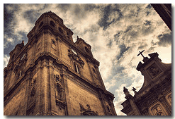
From Prehistory till the Middle Ages, Murcia has gone through numerous cultures that have left their mark and culture, highlighting the old quarter and its cathedral as places to visit.
Murcia, in the 20th century, has gone through a great economical and demographical growth, as well as touristic, becoming one of the most important destinations in Spain.
Murcia attractions
Apart from the already mentioned old quarter and its cathedral as recommended places to visit, the following places are also a must during your stay:
- - Malecon boulevard by the river
- - Saavedra palace from the 17th century
- - Remains of the Arab Wall from the 7th century
Murcia also has numerous mountain ranges for those who seek to feel the natural environment around them and going on a few trekking routes (La Pila and Ricote mountain ranges are situated above 1000 metres high). Undoubtedly, Murcia has a lot of places to visit...do not hesitate to check out our website to discover more about this province and its secrets.